
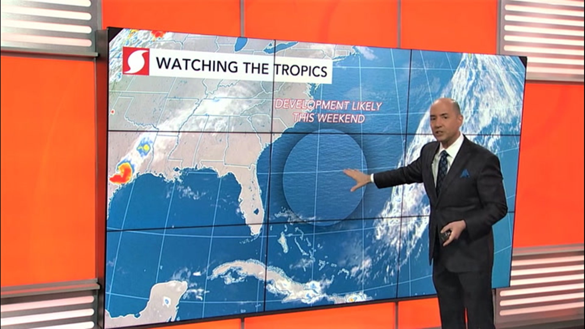
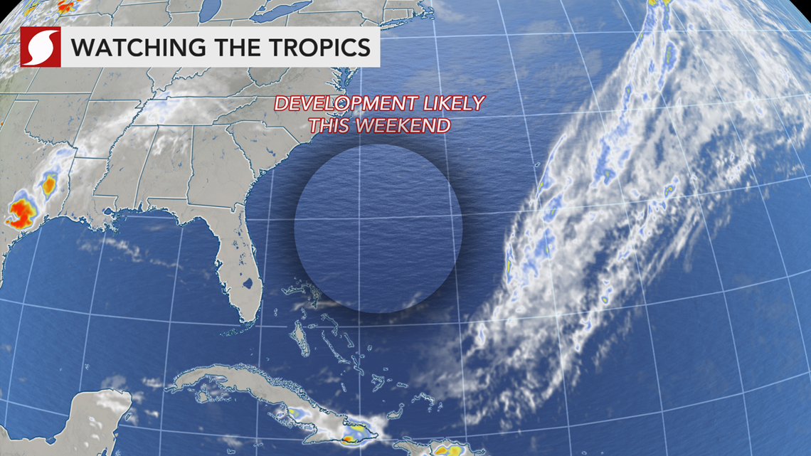
Even though the Atlantic hurricane season doesn't officially start until June 1, the first tropical or subtropical storm is expected to develop offshore of the southeastern United States this weekend.
"In every year since 2012, except for 2014, there has been at least one named tropical system during May," AccuWeather Senior Meteorologist Alex Sosnowski said - and this year is likely to be no different.
AccuWeather meteorologists anticipate a system to begin brewing near South Florida Thursday into Friday before strengthening into a subtropical or tropical system offshore of the Southeast coast this weekend. The ocean water is just warm enough for tropical development.
Friday afternoon a National Oceanic and Atmospheric Administration (NOAA) Hurricane Hunter is scheduled to investigate the system. These missions give forecasters additional insight into the possible future of tropical systems. A Hurricane Hunter test flight was conducted Thursday to calibrate sensors and equipment.

The first tropical storm in the Atlantic Ocean during 2020 will be named Arthur, and it will kick off what is expected to be a "very active" hurricane season by AccuWeather meteorologists.
Subtropical storms are a hybrid of tropical and non-tropical storms, yet these systems are still given names. These storms more commonly develop early and late in hurricane season. Even if a storm is deemed subtropical, it can eventually become fully tropical - a possibility with this weekend's storm.
"We call a storm [like the one expected this weekend] homegrown since it develops close to the coast of the U.S.," AccuWeather Chief On-Air Meteorologist Bernie Rayno said as he described how tropical systems can form before the official start to hurricane season.
Florida, Bahamas likely to face impacts ahead of development
Drenching showers and thunderstorms will douse portions of South Florida and the Bahamas, well in advance of any tropical development.
"As the storm starts to form, it will bring potentially heavy rainfall to parts of the Bahamas and southeastern Florida during Thursday through Friday," AccuWeather Hurricane Expert Dan Kottlowski said.
Downpours can bring travel disruptions and a heightened risk of vehicles hydroplaning when traveling at highway speeds in southeastern Florida, but the Bahamas will face a more elevated risk for flash flooding.

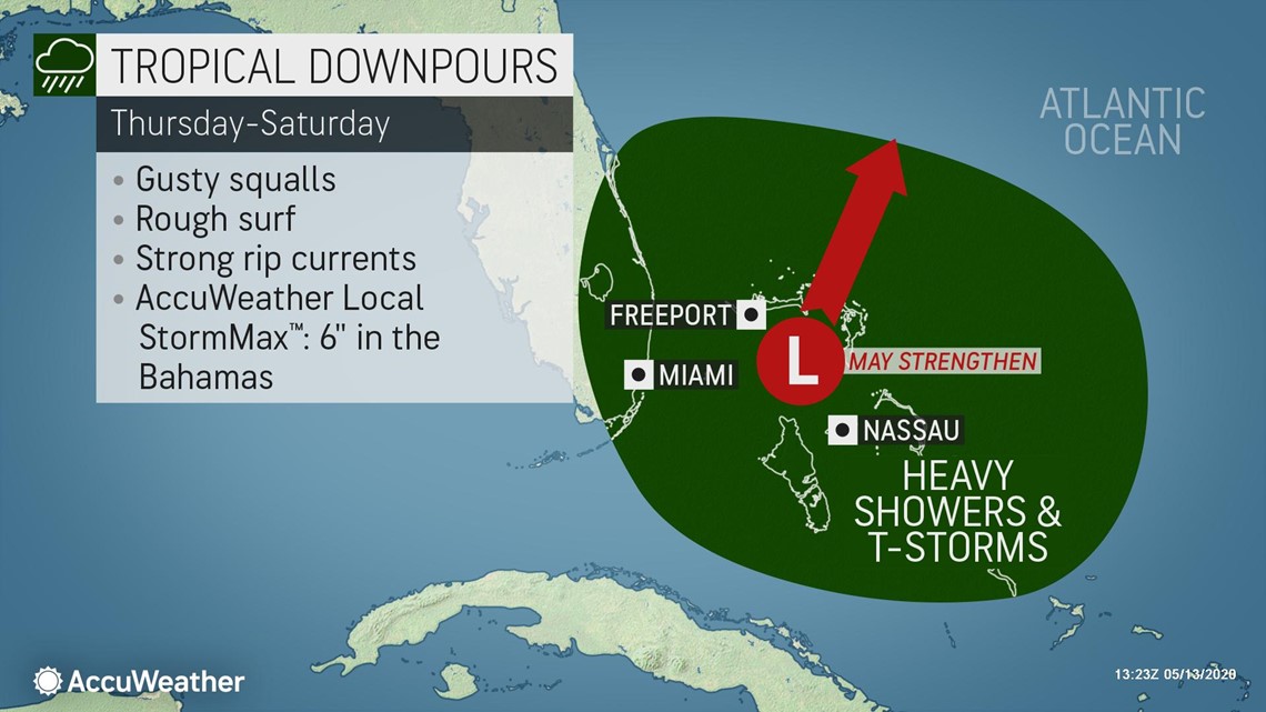
"Before the downpours end later this weekend, there can be an AccuWeather Local StormMax™ of 6 inches (15 cm) in the Bahamas," AccuWeather Senior Meteorologist Rob Miller said.
The storm is expected to stay off the coast of the rest of the southeastern U.S., but impacts can still be felt at the beaches in the form of gusty winds, rough surf and strong rip currents.
"Air squeezing between the budding storm and high pressure to the north will cause seas to start to build later this week at the Southeast beaches and around the Bahamas," Miller said. "Even higher surf may follow this weekend along the coast from Florida to the Outer Banks of North Carolina."
Operators of small craft or beachgoers seeking relief from being pent up in recent months due to concerns of the COVID-19 pandemic will need to be wary of the risks when venturing into the surf due to the likelihood of the increase in the frequency and strength of rip currents.
"What should become Arthur will track northeast and pass just northwest of Bermuda Monday and Monday night as it reaches peak intensity," Kottlowski said. Locally gusty winds and heavy rain can soak Bermuda on Monday, but Kottlowski is not expecting damaging wind to buffet the island.
The system's track should allow the Northeast to escape downpours from this tropical feature, but another storm arriving from the Midwest will soak the region instead, before stalling in the East next week.
The greatest impact what is expected to be Arthur will have on the Northeast will be to bring increasingly rough surf to the mid-Atlantic coast next week. The second storm stalling in the East next week will also add to the rough surf and coastal flooding concerns beyond Arthur.
Other notable May tropical Atlantic storms
Even though the official Atlantic hurricane season spans June 1 to Nov. 30, tropical systems have been observed in every month of the year over the Atlantic, and May is no stranger to the formation of tropical systems, especially in recent years.
"Early-season tropical development occurs differently than during the heart of hurricane season," Rayno explained. "Early-season development happens due to the interaction of the jet stream and the warming waters of the tropics, and that's why we typically see those storms form closer to the U.S."

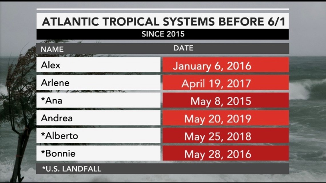
Last year, Subtropical Storm Andrea formed on May 20 well east of the Bahamas before dissipating the next day.
The most recent tropical system to form in May over the same near-shore waters that forecasters are watching now was Tropical Storm Bonnie in 2016. The storm came ashore along the South Carolina coast just east of Charleston in late May, before lingering across the state then turning back out to sea.
In 2012, Tropical Storm Beryl developed in a similar area to the east of Florida. Beryl took a more westward track, cruising into northern Florida toward the end of May, before reversing its course and heading back out open waters of the Atlantic.
Reporting by Alex Sosnowski.