
CONNECTICUT, USA — Each winter presents a new challenge. Last year, we were heading into our third La Niña winter in a row. This year, the script has been flipped, with the return of El Niño.
Connecticut is in a bit of a snow drought. Sure, it's snowed in recent winters, but the last winter with above-average snowfall was six ago (2017-2018). Could that change this year?
It's become a tradition to present the winter outlook with a theme, mixing science, storytelling and engaging graphics. We hope you enjoy our "investigation" into the season ahead!
If you want to skip ahead on this "whodunnit" and see the outlook for this winter, just jump to the conclusion (spoiler alert) at the bottom.
For the weather enthusiasts out there: Keep reading for a more in-depth look at the weather facts we're inspecting this year.
Here are some of the factors we considered:
El Niño
Eurasian snow cover in October
Climate trends
Arctic sea ice
Long-range computer models
Quasi-Biennial Oscillation
Pacific Decadal Oscillation
Analog years
El Niño
The phase of the El Niño Southern Oscillation in the Pacific Ocean is the starting point for most seasonal outlooks, as it can have an impact on weather patterns worldwide.
In the last three winters, we were in La Niña, when the water temperature in the equatorial Pacific was cooler than average. The strong trade winds, blowing west across the equator and upwelling cooler water, have weakened since. As a result, the water over the eastern Pacific has been warming for several months and we are firmly in El Niño.
During an El Niño winter, there is an active sub-tropical or Pacific jet stream. This can bring storminess to the East Coast. At the same time, the polar jet stream often stays north in Canada. This can make colder air harder to come by.
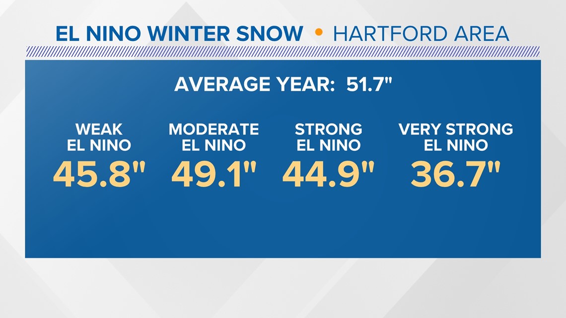
In the Hartford area, less snow than average typically occurs in El Niño winters. There are a couple of larger ones that stick out, including 2002-2003, when 75 inches of snow fell during a moderate El Niño.

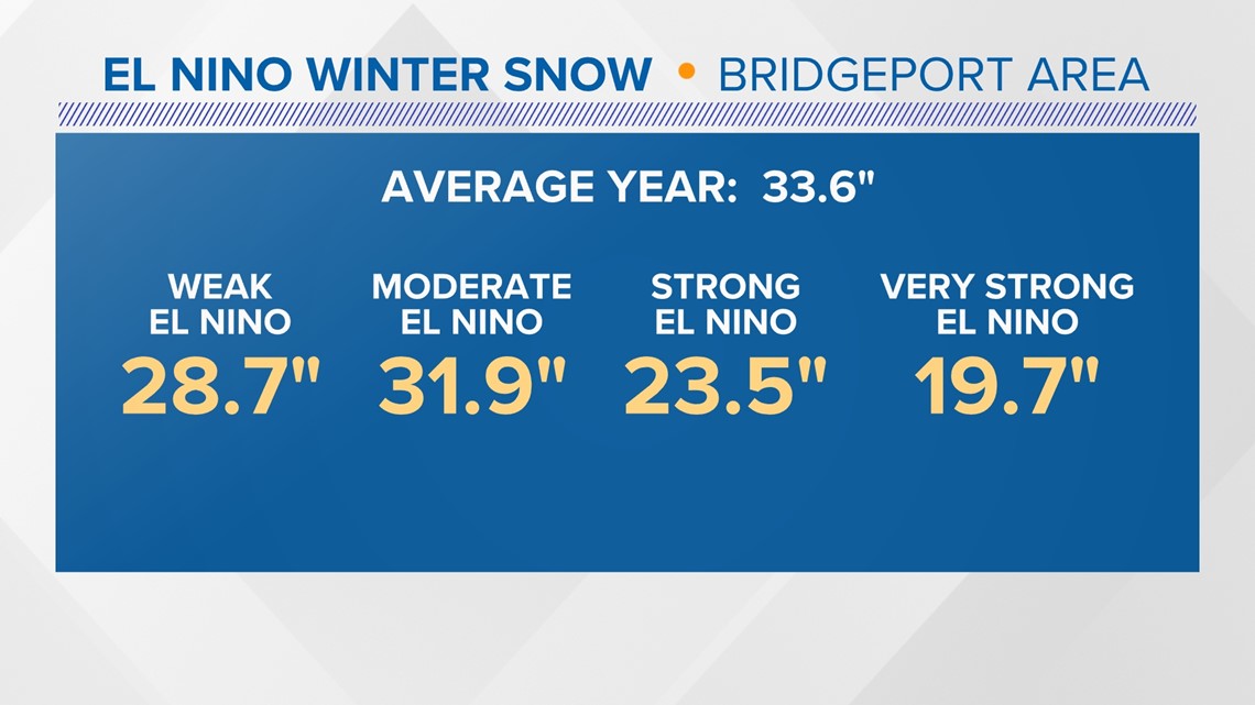
Similar trends are seen on average in the Bridgeport area. However, there's big variability. Some years are booms and others are busts.

But this year’s El Niño may not play out like a typical strong one. Sea surface temperatures are above average in much of the Pacific, not just near the equator. This creates less of a contrast between the El Niño region and the rest of the basin.

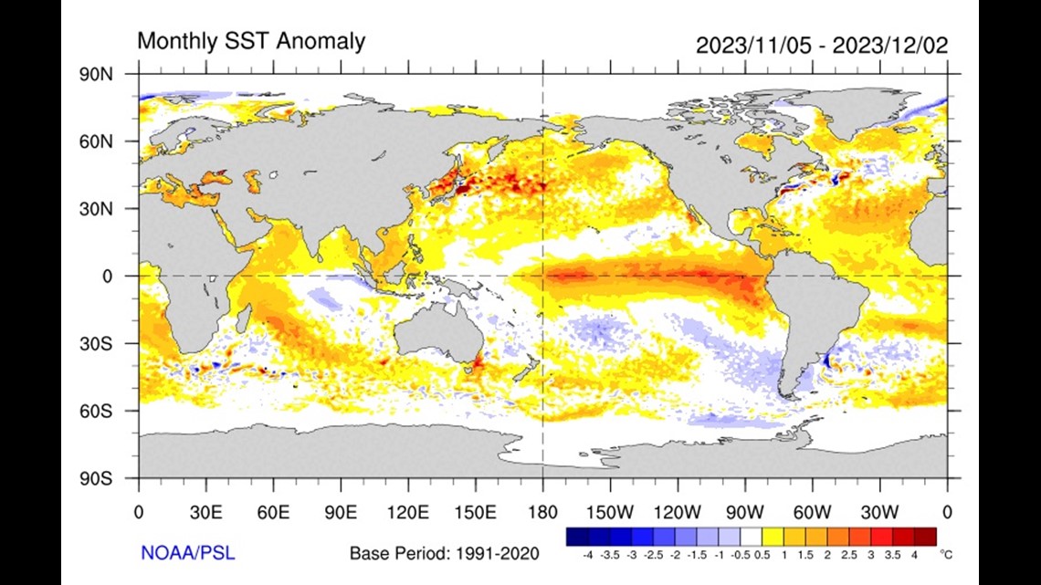
The MEI index, combining both oceanic and atmospheric variables to assess the strength of El Niño, is lower. This suggests the influence of El Niño on the weather pattern may not be as strong as usual. So, it's critical to look at other factors too.
Polar Vortex
Researchers have found a positive correlation between the amount of cold/snow in Siberia during October to the cold/snow in the eastern United States during the winter. The more cold days and snow in October, the weaker the polar vortex becomes, and the more likely that cold can break free and travel south to visit us.
There are conflicting factors here.
Snow cover was low in Siberia during much of October, though it did increase a bit toward the end of the month. This would suggest a stronger polar vortex through the winter, with limited bitter cold outbreaks.
However, the phase of the QBO (Quasi-Biennial Oscillation) has switched since last year. This is an alternative easterly/westerly wind in the tropical stratosphere, and like El Niño, can have far-reaching impacts on global circulation. The QBO is now in its easterly, or negative phase.
Research has shown that during winter with a negative QBO, the polar vortex can be more likely to break down, and influence the amount of high latitude blocking, leading to cold and storminess in New England.
We can't discount that possibility.
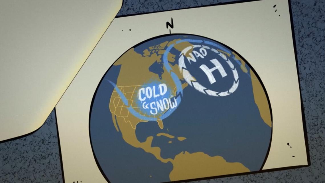
North Atlantic Oscillation
Every winter, meteorologists watch the phase of the North Atlantic Oscillation (NAO). When the NAO is negative, the jet stream gets blocked up over the North Atlantic and Greenland, resulting in a trough or dip in the jet stream over the eastern United States. This can cause storms to slow down and sometimes produce big snowstorms here.
In most winters, it flips back and forth between negative and positive, which usually leads to milder weather here. It can be difficult to forecast these flips until a couple of weeks in advance.
But since July, it's been mostly negative. Last winter, it was largely positive, sparing us of any snowstorms. We believe it could play a role in a couple of bigger storms this winter.

Analog years
Looking back at past years with similar atmospheric players can give an idea of how the winter will play out. In our warming climate, it can be a bit challenging to compare similar-looking winters from 100 years ago, so we looked at five winters in the last 30 years: 1993-94, 2002-03, 2006-07, 2009-10, and 2014-15.
All of these were El Niño winters, with lower MEI indices. A couple of the winters started with a positive QBO that eventually went negative during the winter or spring. They’re not perfect matches, but there are some trends to take away:
In Bridgeport, our climate site for the shoreline: 4 of the 5 winters were snowier than average. 4 of the 5 winters were colder than average.
At Bradley, our climate site for the Hartford area: 3 of the 5 winters were snowier than average. 4 of the 5 winters were colder than average.
In most of these winters, the cold and snow were “backloaded,” with below-average temperatures continuing into four of the five Marches too.
We kept these outcomes in mind when coming up with our outlook.
The Conclusion
As you know, seasonal forecasting is a challenge. But we can take the elements outlined above and come up with a broad idea for how it may play out.
We’re expecting a slower start to winter, with warmer-than-average temperatures in December and January. That doesn’t mean it will be warm all the time. There will be spells of cold between warm-ups.
We think February is the month to watch for colder-than-average temperatures, with a higher risk of cold spilling south.


In an El Niño winter, coastal storms can be favored with a juiced-up sub-tropical jet. However, it all comes down to the track of those storms. Sometimes in these winters, the storm track can be suppressed to our south, hitting the Mid-Atlantic or even southern Connecticut more than the rest of New England. However, if everything lines up with a negative NAO, we could be in the sweet spot for a couple of bigger storms.
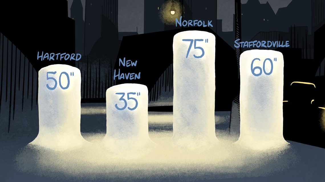
All told we’re expecting snow totals to be close to average. Compared to last year this may seem like a lot, especially near the shoreline where barely any snow fell last year!
Hartford area: 50” (Average is 51.7”)
New Haven area: 35” (Average is 33.6”)
Staffordville area: 60” (Average is 65")
Norfolk area: 75” (Average is 75")

Only time will reveal the chilling mysteries that winter conceals.
The FOX61 Weather Watch team will be with you every step of the way!
Rachel Frank is the chief meteorologist at FOX61 News. She can be reached at rfrank@fox61.com. Follow her on Facebook, X and Instagram.
Ryan Breton is a meteorologist at FOX61 News. He can be reached at rbreton@fox61.com. Follow him on Facebook, X and Instagram.
---
Have a story idea or something on your mind you want to share? We want to hear from you! Email us at newstips@fox61.com
----
HERE ARE MORE WAYS TO GET FOX61 NEWS
Download the FOX61 News APP
iTunes: Click here to download
Google Play: Click here to download
Stream Live on ROKU: Add the channel from the ROKU store or by searching FOX61.
Steam Live on FIRE TV: Search ‘FOX61’ and click ‘Get’ to download.