
HARTFORD, Conn. — A nor'easter is hitting Connecticut this weekend and like any good forecast, some things have changed.
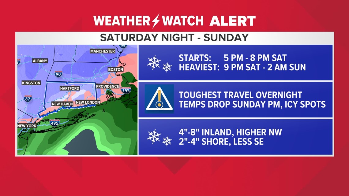
The storm looks like it will arrive in the Nutmeg State a few hours earlier than previously advertised and the heaviest snow will fall Saturday night. The lighter snow will continue during the day on Sunday.
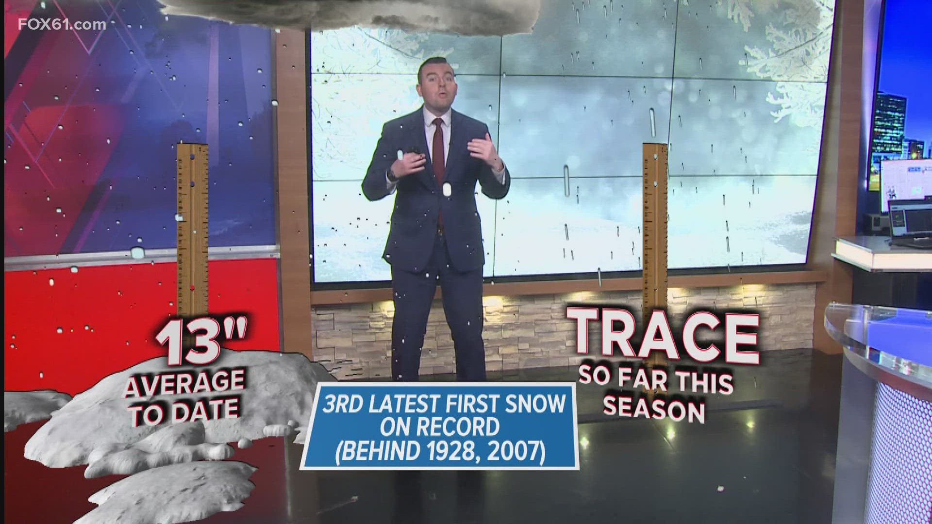
This is an El Niño winter, which often leads to a juiced-up subtropical jet stream. We've seen that with the rainstorms over the last few weeks. When a storm forms in the right place at the right time, with enough cold air, it can lead to snow here in southern New England. We discussed this in our winter outlook.
FULL FORECAST: Tracking a weekend winter storm
Currently, there is a winter storm warning in effect for most of the state where there is a chance for 6" of snow. A winter weather advisory is in effect for the shore of New Haven and Fairfield counties. A winter storm watch is in effect for inland New London and Middlesex counties where there is less confidence in some of the higher 6"+ totals.

Here is everything we know about the timing and impacts:
- Saturday will remain dry during the day with cloudy skies and temperatures in the 30s. Snow won't develop until Saturday evening after sunset.
- Snow starts Saturday night between 5 p.m. and 8 p.m.
- Heavier snow develops after 9 p.m. and lasts until about 2 a.m. Sunday morning.
- There could be some impressive snowfall rates, up to 1-2" per hour. This is when road conditions could be the most difficult.
- After midnight, some mixing is possible at the shoreline and in southern Connecticut
- Snow will be lighter by Sunday morning. Some roads will be slippery and snow-covered before plows can get out and clear.
- There is a chance for minor accumulation to continue on Sunday afternoon
- The snow will taper off through the afternoon.
- Temperatures will be dropping during the day on Sunday. This means areas that don't see a lot of snow will need snow melt or salt as areas could ice up
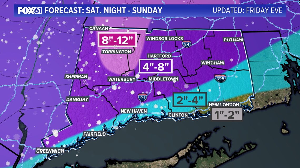
Snow accumulation
The majority of the state is digging out after this one! 4"-8" of snow is expected for most of the state.
Some lower amounts are expected towards the shoreline and southeast Connecticut where some mixing is likely. Most of this snow is on the front end thump Saturday night.
Some minor accumulation is possible on Sunday during the day too.
Northwest Connecticut is likely to get the most snow.

Ryan Breton is a meteorologist at FOX61 News. He can be reached at rbreton@fox61.com. Follow him on Facebook, X and Instagram.
Rachel Frank is the chief meteorologist at FOX61 News. She can be reached at rfrank@fox61.com. Follow her on Facebook, X and Instagram.
---
Have a story idea or something on your mind you want to share? We want to hear from you! Email us at newstips@fox61.com
HERE ARE MORE WAYS TO GET FOX61 NEWS
Download the FOX61 News APP
iTunes: Click here to download
Google Play: Click here to download
Stream Live on ROKU: Add the channel from the ROKU store or by searching FOX61.
Steam Live on FIRE TV: Search ‘FOX61’ and click ‘Get’ to download.